What is this about?
Temperatures higher than 42°C (107.6°F) can kill flying-foxes ('fruit bats'; Pteropus sp.) at sometimes biblical scales. For example, on just one extremely hot day in January 2014, at least 45,500 flying-foxes died in 52 camps in southeast Queensland (Australia), wiping out about half of all black flying-foxes (Pteropus alecto) that were present in the affected area. More recently in November 2018, approximately 23,000 spectacled flying-foxes (P. conspicillatus) died during a single heat event in Far North Queensland. These deaths represented about one-third of Australia's entire spectacled flying-fox population, raising serious concerns regarding the conservation of this now-endangered species.
To aid wildlife rehabilitators, land managers, and other stakeholders in coping with such events, our team from Western Sydney University and the University of Melbourne has developed a flying-fox heat stress forecaster. The forecaster predicts the camp (roost) locations where flying-foxes are likely to experience extreme heat, up to 72 hours into the future. The forecaster uses computer model weather data made available by the Australian Bureau of Meteorology via the NCI-sponsored Data Collections archive, with flying-fox camp data from the National Flying-Fox Monitoring Program. For details on the forecaster's accuracy and precision, see our paper in Animal Conservation. The outputs of the forecaster include up-to-date maps of affected areas, hourly temperature profiles of affected camps, and a list that prioritises known camps by date, maximum temperature and the number of flying-foxes present. These are designed to direct stakeholders towards where and when flying-fox die-offs are most likely to occur, to facilitate efficient allocation of resources and help minimise impacts on human communities and flying-foxes alike. |

|

Latest temperature forecasts for Australia

Animated GIF showing the current and predicted temperatures on the Australian continent within the three-day forecasting horizon. Predictions are based on computer model weather data from the Australian Bureau of Meteorology, and flying-fox camp locations (•) are derived from the National Flying-Fox Monitoring Program.
Areas on high alert (T ≥ 42°C)

|
 |
 |
Daily maps showing areas where temperatures are predicted to exceed 42°C in red. The maps can be loaded into Google Earth Pro (or similar) via their associated KMZ links.
Daily list of flying-fox camps where heat stress (T ≥ 38°C) or mortality (T ≥ 42°C) is likely
|
Note that:
|
Temperature profiles of camps where heat stress is likely to be worst
Legend: --- 38°C (heat stress threshold) --- 42°C (mortality threshold) o hours at ≥ 42°C (mortality threshold) --- twelve hour periods --- one hour periods
|
Note that:
|
Background information
|
Flying-foxes and extreme heat events
Flying-foxes are charismatic, very large species of bat that forage by night and roost by day in arboreal roosts that can comprise tens of thousands of individuals. They provide important ecosystem services, including pollination of wild and cultivated crops and seed dispersal (e.g. Fujita & Tuttle 1991). However, they are exposed to threatening anthropogenic factors (Mickleburgh et al 1992), the most serious of which are loss of foraging and roosting habitat (e.g. Tidemann 1999), direct killing of animals in orchards and harassment and destruction of roosts (e.g. Tidemann & Vardon 1997; Welbergen & Eby 2015). Our research has shown that temperatures exceeding 42ºC cause mass mortality among flying-foxes at landscape scales, with profound effects on the behaviour and ecology of the species. These extreme temperature events affect some flying-fox species more than others, with the more tropical P. alecto showing higher rates of mortality than the more temperate P. poliocephalus. The events are also age-class and sex specific, with dependent young and lactating females predominantly affected. So far we have found evidence of at least 39 flying-fox die-off events in Australia, with the earliest dating back to 1791, but the majority (35) occurring since 1994. At least 20 events had a death toll in excess of 1,000. In these 20 substantial events, over 163,300 flying-foxes died, with at least 131,000 casualties since 2011. Currently, flying-fox die-offs occur between 0-5 times per year, but these events are expected to escalate under climate change, with disturbing implications for flying-foxes and other organisms in Australia and beyond. |
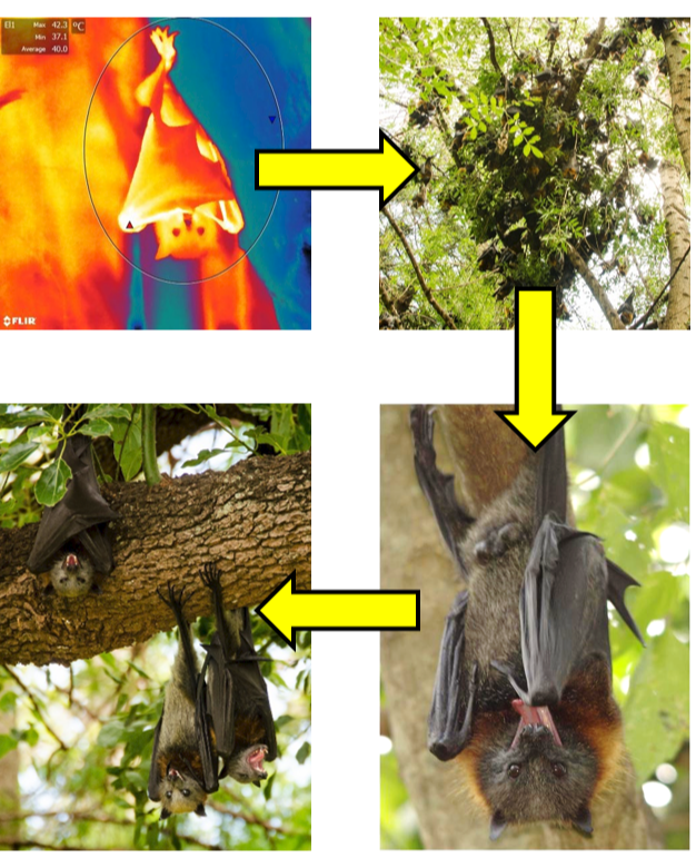
Flying-foxes show a predictable sequence of thermoregulatory behaviours with rising temperatures (clockwise: wing fanning, clustering, salivating, panting). Beyond 42º C, thermoregulatory mechanisms become overwhelmed and this is soon followed by death (Welbergen et al 2008).
|
The flying-fox heat stress forecaster
|
For our simulations we use forecasted air temperature data from the Bureau of Meteorology’s Australian Regional domain of the Australian Community Climate and Earth-System Simulator (ACCESS-R) Numerical Weather Prediction (NWP) system. This system has a region-wide resolution of about 12km and runs four times per day (00Z, 06Z, 12Z & 18Z base times) out to a forecast hour of +72.
Information on flying-fox camp locations and occupancy are obtained from the National Flying-Fox Monitoring Program. These data provide the locations and relative sizes of camps that are most likely to be occupied at the present time of year. Every six hours we obtain the latest available ACCESS-R air temperature forecast from the NCI Data Collections archive. Prediction analyses are then implemented in the R programming environment to detect flying-fox camps exposed to air temperatures above 38°C (heat stress threshold) and 42°C (mortality threshold). Our scripts then generate a suite of outputs, including the maps, camp temperature profiles, and camp priority lists displayed on this website. For details on the methodology, and the accuracy and precision of our forecaster, see our publication in the journal Animal Conservation. |
 Animated GIF showing forecasted temperatures in eastern Australia, mapped from Australian Bureau of Meteorology computer model data.
|
Useful links
Extreme heat events vs. flying-foxes:
- The impacts of extreme temperature events on Australian flying-foxes: examining heat-related wildlife die-offs in a warming world. (ongoing research program, Western Sydney University).
- Estimating flying-fox mortality associated with abandonments of pups and extreme heat events during the austral summer of 2019–20. Pacific Conservation Biology - https://doi.org/10.1071/PC21003
- Forecasting wildlife die-offs from extreme heat events. Animal Conservation 22 (2019): 386–395
- Climate change and the effects of temperature extremes on Australian flying-foxes. Proceedings of the Royal Society of London, Series B 275 (2008): 1817-1822
- Killer climate: tens of thousands of flying foxes dead in a day The Conversation, 24-2-14
Management responses:
- A review of intervention methods used to reduce flying-fox mortalities in heat stress events. Australian Mammology 43(2): 137-150
- Responding to heat stress in flying-fox camps (NSW Office of Environment)
- Flying-fox heat stress management (J. A. Welbergen)
Health and safety first!
NSW Government (Heat-related illness including heatstroke); NSW Government (Beat the heat – information for health professionals); NSW Government (Beat the heat – How to stay healthy in the heat); Life Saving Victoria (Heatstroke); Northern Territory Government (Guidelines to prevent heat stress); Smartplay & SunSmart (UV exposure and heat illness guide); RSPCA (What can I do in hot weather to prevent heatstroke in my pet?); SA Government (Extreme heat)
NSW Government (Heat-related illness including heatstroke); NSW Government (Beat the heat – information for health professionals); NSW Government (Beat the heat – How to stay healthy in the heat); Life Saving Victoria (Heatstroke); Northern Territory Government (Guidelines to prevent heat stress); Smartplay & SunSmart (UV exposure and heat illness guide); RSPCA (What can I do in hot weather to prevent heatstroke in my pet?); SA Government (Extreme heat)
For general maps of impending heat waves with implications for human health and infrastructure, see the Heatwave Service from the Bureau of Meteorology.
Attributions & acknowledgements
Conception: Justin Welbergen, Luke Shoo, David Karoly, Mike Kearney
Scripts: Mike Kearney, Himali Ratnayake, Pallavi Govekar, Stewart MacDonald
Web design: Justin Welbergen, Himali Ratnayake
Many thanks to Kamal Puri and Robin Bowen from the Australian Bureau of Meteorology for their help and for kindly making the hourly temperature forecasts available, and Tan Le who for making the datasets resident at NCI and keeping them up-to-date. Many thanks also to Adam McKeown and David Westcott for providing access to the National Flying-Fox Monitoring Program data.

|

|

|

|

|
Necessary disclaimer
Our flying-fox heat stress forecasts are based on best-practice landscape-scale weather predictions from computer model data. Nevertheless, the predictions may under- or overestimate maximum temperatures, especially at the small scale of individual flying-fox camps. In addition, they may exclude camps that are currently occupied, and, conversely, include camps that are currently unoccupied. We cannot accept any responsibility for the loss or damage that may result from reliance on, or the use of, any information contained on this webpage.
THIS IS A WORK IN PROGRESS!